Saturday
Mar202010

Trip Report: Grand Canyon National Park

The big one. The one "must see" national park. For years I postponed this trip, believing the hype that this was something better seen in books or on television. While it is true, your pictures are not going to rival those in a travel brochure, no picture truly captures the immensity of this wonder.

Never Ending Route 64
Arizona Rt-64 North


Route 64 is the main artery used by canyon tourists coming from Flagstaff and other points South. The road is flat and straight, but definitely not boring. Every thirty or so miles you come upon some civilization, be it gas stations, farms, or other points of interest. Together they help one imagine what taking a vacation in the United States must have been like in the 1950s: Long empty stretches of road with only occasional signs of civilization.

Fred Flintstone's Diner
Fred's Diner, Rt-64, Williams, AZ


This motif continues up to park's entrance, even the two fast food restaurants don't seem too out of place. The Red Feather Lodge, where I stayed, definitely played to the road trip tune, reminding me of the motels from my childhood roadtrips.

Red Feather Lodge Postcard


Tip:When staying at the Grand Canyon, the best rates are always found outside the park. However be sure to take driving distance into consideration. Valle and Williams are about 45 and 70 minutes away, respectively, whereas Tusayan (and the Red Feather Lodge, among others) is only 5 minutes away.

Grand Canyon


Nothing can prepare you for the scale of the Grand Canyon. Pictures capture its beauty, but fail in capturing its immensity.

Grand Canyon


Tip: Don't miss the sights on the Hermit's Rest portion of the rim trail. Although most visitors skip this section, I spent the majority of my time here watching Ravens play in the wind rushing up the cliff sides. For views, Trailview and Pima Point were my favorites and Hopi Point is recommended as THE sunset location.

Hermit Rest Rim Trail (with Canyon in background)
Paved portion of the Rim Trail on Hermits Rest Route


At night, the canyon's personality changes. There are no sounds of civilization, no light; it's just you, darkness, and on a clear night, stars. More stars than I have ever seen.

On the rim, you see mile upon mile of blackness, only occasionally interrupted by the small light of a campsite or ranger's vehicle. But all is not silent, you occasionally hear the wind, as it slowly whips around the canyon, until it briefly envelops you.

And then slowly, silently, the sky in the west starts to get definition. Equally as slowly, the first tourists of the day start to arrive to great the sun and another day begins.
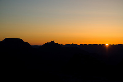
Sunrise over the Grand Canyon
Spring Solstice Sunrise from Mather Point
Saturday
Mar132010

Trip Report: Red Rock State Park

In an effort to close a massive budget shortfall, Arizona has decided to close all but nine of their state parks. Red Rock State Park, unfortunately, is one of those on the wrong side of that equation.


Without a doubt, this was the best State Park I have ever visited. The facilities were extremely well maintained; the Rangers were friendly and extremely helpful. Every trail was very clearly marked with conspicuous signs, as well as "you are here" maps. All things you look for when taking a family hiking.

And yet, in spite of this, I met very few people on the trails. A group of bird watchers mulling around Oak Creek and a solitary retiree on the Coyote Ridge Trail were the only other people I saw in the morning. By the end of the day, I would cross paths with only six other groups.

This meant the trail was generally devoid of human noise; in fact in most cases the only noise was that of the creek. Without the chirping of birds, or rusting of squirrels, it is easy to forget you are in a wild habitat.

On Eagle's Nest Trail, just after leaving the Coyote Ridge, I was reminded of this when I accidentally startled a pair of Javelina. Although I came within 10 feet of a mother and her child, the first hint I had of their presence was when the mother snarled and thundered away, her offspring in close pursuit.


More pictures on my Google+ site.


All in all I had a great time, and am saddened to see the closure of such a great park. If you have the means, I strongly suggest visiting the park before it closes in June of 2010.

Red Rock Tracks
View on Google Maps.


Distance: 5.6 miles
Time: 3 hours 20 minutes


Sunday
Sep202009

Trip Report: White Mountains, NH - Pemigewasset Wilderness

18 Sept 2009.

The plan. The plan was achievable. The plan was to hike the Lincoln Woods Trail to Franconia Falls, swing by Shoal Pond and Thoreau Falls before heading back. Four Days. 26 miles. Under 6.5 miles a day. Easy.

I was hiking with an inexperienced individual who had back surgery less then a year ago. The emphasis was on balancing ease with picturesque. Build an experience that wouldn't tax the system.

(East Branch) Pemigewasset River, Bondcliff in the background (East Branch) Pemigewasset River, Bondcliff in the background

We started out slowly, chatting, stopping to take pictures (like the one above). There was no rush.

Lincoln Woods Trail (after Osseo Trail) Lincoln Woods Trail (after Osseo Trail branch off)

The tenor of the hike changed shortly after the Osseo trail branched off. The breaks became more frequent, the conversation less so.

When we reached the Black Pond Trail and I happily announced our proximity to Franconia Falls. Unfortunately, that distance was to great. Back pain, which had been slowly building, had now reached the point where my companion was concerned about making the trip back to the car. So, 2.6 miles in, the "easy" camping expedition was canceled and efforts were made to ensure a successful return trip (eating, hydrating, and transferring the injured persons pack to the non-injured).

The return trip was quick, despite stopping frequently to rest (and take Pemi pictures), and uneventful. Exactly what you want when a team member is nursing an injury.


(East Branch) Pemigewasset River facing south

White Mountains - Pemigewasset Wilderness


Distance: 5.2 miles
Time: 3 hours 20 minutes
AMC 4k peaks: N/A
Saturday
Sep192009

Trip Report: White Mountains, NH - Franconia Ridge Loop

12 Sept 2009.

In preparation for a White Mountain Camping excursion, on the 12th of September, I set off to solo the most popular Franconia Ridge loop: Falling Waters Trail to Little Haystack Mt to Mt. Lincoln to Mt. Lafayette to Greenleaf Trail to the Old Bridle Path. The day was long, about eight and a half hours, but the visuals were stunning.

Small Waterfall on the Falling Waters Trail

 Falling Waters Waterfall The first waterfall on the Falling Waters Trail

Although rain pounded southern New Hampshire and Massachusetts, the skies were clear when I arrived at the White Mountains. However as I ascended Little Haystack Mountain, the clouds started to roll in. So much so, the view from the top of Little Haystack was less then picturesque.

Franconia Ridge Trail, seen from Little Haystack Mt Franconia Ridge Trail, seen from Little Haystack Mt


After resting and eating at Little Haystack's summit, I decided to continue on to Lincoln. The last bit of Falling Waters was extremely steep and far more difficult than I expected. I was slightly concnered, if Falling Waters was the AMC's idea of an easy trail, I wasn't looking forward to meeting a "difficult" one.

I followed the trail blindly, the low clouds obscuring the mountains ahead, in near perfect silence occasionally interrupted by the sound of hiking poles striking rock and then voice.
A tired hiker on Mt. Lincoln A tired hiker on Mt. Lincoln
The surrealism cannot be adequately explained. I was hiking on the most popular trail, seeing only 100 yards around, no other people, no sounds of people, silence only interrupted by the sounds I made. And then suddenly (and only occasionally) the dragging sound of hiking poles on rock, a voice or voices, and moments later a figure in the fog.

Rt-93, as seen from the Greenleaf Trail. Rt-93, as seen from the Greenleaf Trail.

White Mountains - Franconia Ridge - 03
White Mountains - Franconia Ridge Album


Distance: 8.5 miles
Time: ~8.5 hours
AMC 4k peaks: Mt. Lincoln, Mt. Lafayette
Monday
Aug172009

Ride Report: Mass Pike Tour - Day 4

09 Aug 2009.

A thick fog hung over the field as the riders slowly woke up for the last day; slowly meandering towards breakfast.

By the rider meeting, the fog had lifted to reveal a cloudless sky; however rain was predicted for the afternoon, so everyone wanted to get on the road quickly.

As the rider meeting droned on, a bank of storm clouds advanced across the sky; so much so that in less than an hour the blue sky had disappeared. The threat of rain was suddenly very real.

Once again, we departed in two waves. However, unlike every other day, nearly all the riders left with the first wave. The ride started slowly, riders warming up and testing their legs, but quickly evolved (once again) into a paceline.

Once the first paceline formed, attrition whittled the group until there were just 9: Howie, Lee, Sean, Steve, Ellen (from Day 1), David (from Day 3), Steve (whom I hadn't ridden with before), Gary (who worked for DCR, lived nearby, and was just riding with us on the last day), and myself.

Very quickly, Steve (new Steve) and Gary demonstrated their strength with long fast pulls on the front, so much so small gaps started to form in our paceline. Nothing serious, but enough that stronger riders filled the gaps, rather than cycle all the way to the back.

The pacelining continued until it was broken up by the day's only real climb, a four mile never-ending hill. One by one we suffered up this relentless hill, knowing what payoff waited at the top. 10 miles of descending. After a brief respite at the summit, the group raced down to the last rest stop.

The after-stop pacelines were far quicker than before, assisted by hills and rider motivation.

When I was handed my pull, I struggled to keep the pace high as I hammered into a headwind. After what felt like a miserably short pull, I pulled off to cycle back expecting to coast back 8 riders.Unfortunately my "miserable" pull had detonated our little group leaving only two riders (Sean and new Steve) on my wheel. This was going to be a very short recovery.

Together the three of us dug deep to keep the pace up. In no time, we were reeling in the 30 milers and then, the ride was done. We had reached the school; tired but satisfied. Not to long after we finished, as we were packing our bikes, a short small rain shower passed. We had beat the rain! A great way to end a great tour!


Distance: 54 miles
Climbing: 3120 ft
Ave Speed: 16.4 mph
Max Speed: 41.4 mph
Time: 3 hours 14 minutes 48 seconds